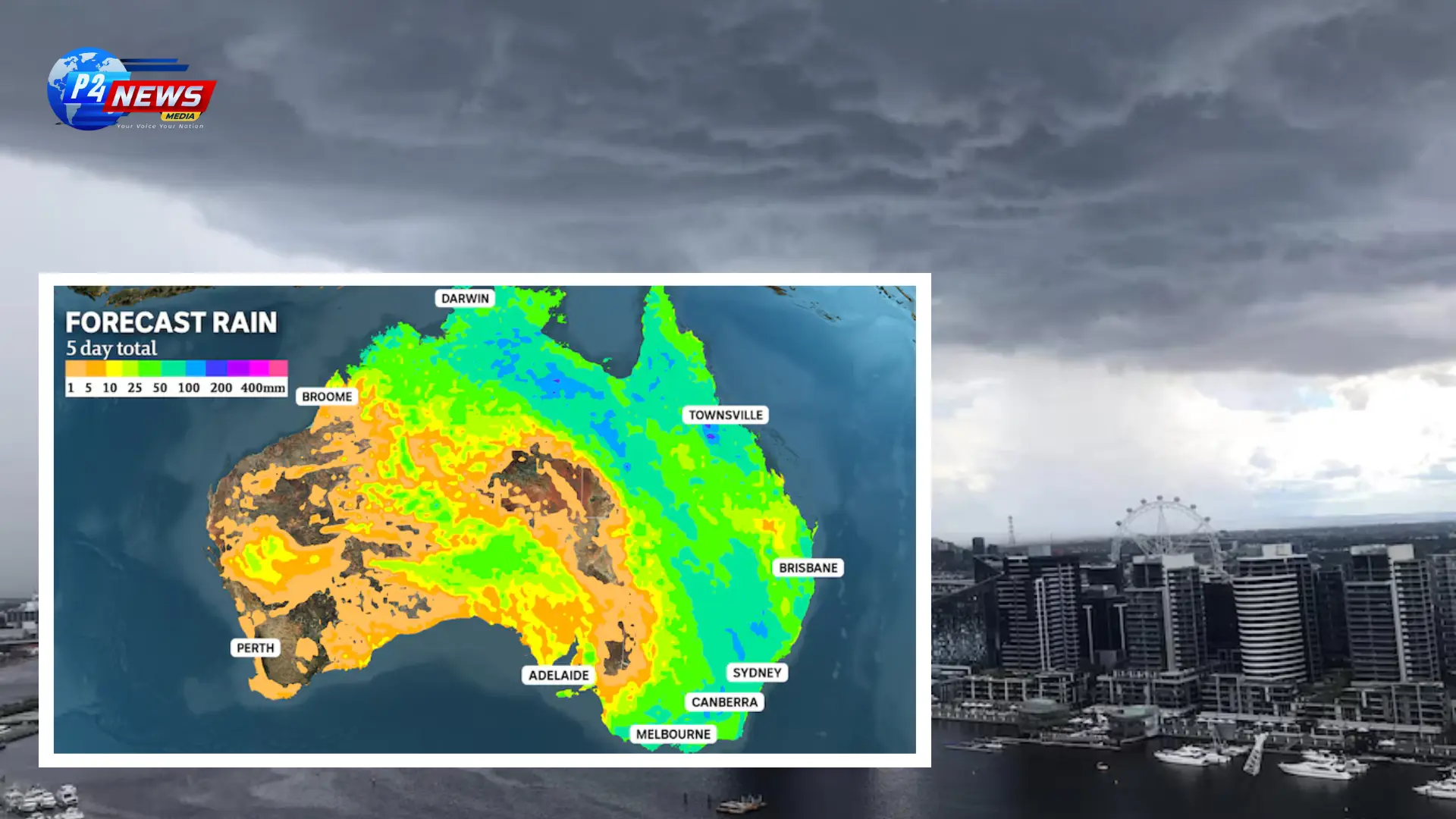
Severe storms unleashed torrential rain and strong winds in Melbourne this Wednesday, with reports of flash flooding and damaging winds expected across multiple states in the coming days. Areas like Brisbane, Sydney, and Canberra are set to experience extreme weather, as a significant cloudband delivers intense downpours across the region.
Eastern Australia is bracing for an extended series of thunderstorms, which will result in flash floods, hail, and strong winds over the coming days. This system is characterized by a massive cloudband stretching 4,000 kilometers—from the northern Top End down to Tasmania—producing torrential downpours as the spring season reaches its conclusion. Major cities such as Brisbane, Sydney, Canberra, Melbourne, and Hobart face a direct threat this week, with the Murray-Darling Basin and parts of the tropics potentially receiving rainfall amounts exceeding 100 millimeters.
New South Wales (NSW) will begin to see relief from a brutal heatwave, which has contributed to the longest sequence of hot spring days on record in western Sydney, as the rains arrive. The rain, which has already been felt in various parts of the states, is a welcome change from the extreme heat that has conflicted with the typical climate of the area during this time of year.
The recent warm and humid tropical air mass originating from the north has already caused record-breaking rainfall in northern South Australia and northwestern Victoria throughout the previous week. The cloudband is continuing its easterly movement, with Tasmania receiving significant rain on Wednesday and severe thunderstorms developing in Victoria and inland NSW.
On Wednesday, Melbourne experienced 24mm of rain early in the day, and later afternoon storms led to a striking 106 kilometer-per-hour wind gust at Fawkner Beacon, with Clayton seeing 43mm in just half an hour. The system is projected to progress slowly, spreading severe thunderstorms across the NSW coast to western Queensland.
The Bureau of Meteorology (BOM) issued warnings indicating an increased likelihood of severe thunderstorms in Sydney on Thursday. The current weather patterns and conducive airstreams create a perfect environment for the development of rapid and intense storm cells. There is an anticipation of over 50mm of rainfall in only a few hours concerning the significant moisture in the atmosphere and the relatively slow migration of storm cells.
From Friday through Sunday, heavy downpours are expected to continue along the eastern side of the country, spanning from Cape York down to Hobart. Generally, storms tend to dissipate after a day or two; however, this particular weather system will remain stalled for several days, ensuring a steady influx of tropical moisture due to prevailing northerly winds.
Forecasts suggest that after Thursday, the rainiest days will likely be Friday or Saturday for Sydney, Saturday for Canberra and Melbourne, followed by Brisbane and Hobart on Sunday. This series of storms is likely to elevate weekly rainfall totals to an impressive 50 to 100mm nationwide, representing the most extensive rain event for Australia since autumn. Localized areas may record higher totals exceeding the 100mm mark, particularly where intense storm activity occurs.
The anticipated heavy rainfall poses a risk of flash flooding, which could lead to short-term inundation in urban areas. A Flood Watch was already initiated for the Barkley district in Northern Territory, and additional warnings may soon be issued for regions in inland NSW, northeastern Victoria, and Tasmania. Following last week’s heavy storms, southern Queensland is already experiencing some inundation.
Fortunately, one of the upsides of this rain is the potential to reduce fire hazards in eastern and northern Australia while gradually alleviating the severe heatwave gripping NSW. The extreme heat peaked on Wednesday, with temperatures soaring to levels 14 degrees Celsius above average, marking the hottest spring in four years for several suburbs, including Penrith, which recorded five consecutive days exceeding 35C for the first time since records began in 1995.
As the cool southerly winds are expected to move in next week, cloud cover during the forthcoming days will offer temporary relief, bringing maximum temperatures down to the mid-20s in Sydney for Friday and Saturday. However, despite this respite, high humidity levels will likely sustain muggy conditions throughout the weekend, with nighttime temperatures remaining above 20C. Once the skies clear on Sunday, daytime temperatures are projected to quickly rebound above 30C, emphasizing the ongoing variability of Eastern Australia's climate.


Comments 0